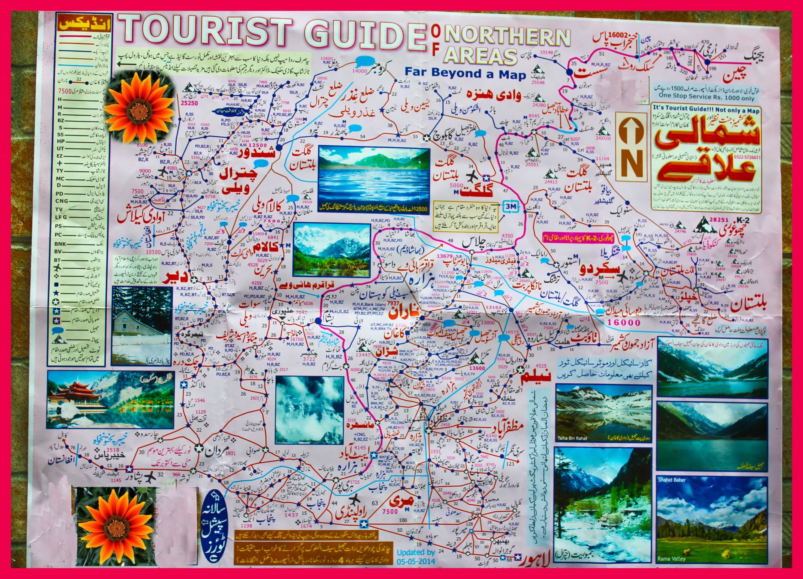
Pakistan’s Northern Areas are nothing short of heaven on earth. Whether you are a seasoned traveler or a first-time explorer, this region offers an unmatched experience filled with towering mountains, lush green valleys, gushing rivers, alpine lakes, ancient cultures, and unforgettable adventures.This map — “Tourist Guide of Northern Areas – Far Beyond a Map” — is your visual passport to some of the most stunning destinations in the world.—🌍 Key Regions Highlighted on the MapThe map unfolds a well-connected network of roads and trails leading to the most famous and lesser-known tourist gems of the north. Here’s what you’ll find:—🏔️ Gilgit-Baltistan – The Roof of the WorldSkardu (7500 ft): The gateway to K2 and some of the world’s highest peaks. A base for adventurers aiming for Concordia, Baltoro Glacier, and Snow Lake.Hunza Valley: One of the most celebrated valleys, known for Altit and Baltit forts, Karimabad, and Passu Cones. Heaven for photographers.Fairy Meadows & Nanga Parbat Base Camp: One of the most scenic treks with panoramic views of the killer mountain.Khunjerab Pass (15,397 ft): The highest paved international border crossing in the world between Pakistan and China.Ghizer Valley, Phander Lake, and Yasin Valley: Lesser-traveled paths for peace-seekers and trout fishing lovers.—🌿 Azad Jammu & Kashmir – The Green WonderlandNeelum Valley: Curving river, pine-covered slopes, and charming villages like Kel and Arang Kel make this valley one of the most beloved.Leepa Valley: Accessible via Reshian, it offers serenity and unmatched views, especially in autumn.Rawalakot, Banjosa, and Toli Peer: Quick getaways for families from Islamabad and Rawalpindi.—🌄 Swat, Dir & Chitral – Valleys of LegendsSwat Valley: Rich in history and beauty — visit Malam Jabba, Kalam, and Mahodand Lake.Chitral & Kalash Valleys: Home to the ancient Kalash people, their unique culture, and festivals.Shandur Pass (12,500 ft): World’s highest polo ground where the Shandur Polo Festival is held every July.—🚩 Iconic Mountain PeaksThe map outlines major peaks and trekking zones:K2 (28,251 ft) – The second-highest peak in the world.Nanga Parbat (26,660 ft) – The western anchor of the Himalayas.Rakaposhi, Spantik, Ultar, and Gasherbrum peaks – Trekkers and climbers’ dream destinations.—🌊 Lakes & Rivers That Breathe LifeThe map features breathtaking lakes including:Satpara Lake (Skardu)Attabad Lake (Hunza)Rama Lake (Astore)Rush Lake (One of the highest alpine lakes)—🛣️ Road Networks & RoutesThe map guides through important highways and roads like:Karakoram Highway (KKH) – The spine of Northern travel.Naran–Babusar–Chilas Road – Connecting Kaghan Valley to Gilgit-Baltistan.Gilgit–Skardu Road, Chitral–Dir Road, and Astor–Deosai Plains.—🧭 Tourist Services & IconsThe legend shows key services including rest houses, police check posts, petrol stations, bus stations, hotels, banks, and communication towers — making it extremely useful for planning.—📸 Tourism Beyond SightseeingNorthern Pakistan is not just about landscape — it’s culture, heritage, hospitality, and resilience. From the ancient Silk Route connections in Hunza to the untouched Kalash traditions, every mile is a story.—🔖 Why Use This Map?Updated with local insights as of 05-05-2014Routes and distances are clearly markedVisuals of lakes, valleys, and mountain zonesIdeal for road trips, backpackers, trekkers, and families—✨ Final Words from PakJourneyIf you dream of turquoise lakes, snowy peaks, deep green meadows, and historic paths walked by poets and travelers for centuries — the Northern Areas of Pakistan are calling.Plan your next adventure with the help of this tourist guide map and let PakJourney take you through the stories, views, and hidden trails of the north.

